Puerto Rico Sustainability Report
Puerto Rico Still Needs Our Help
Over the course of this semester, I have been a part of a class that has been researching, visiting, and assessing the state of Puerto Rico following the devastation of Hurricane Maria. I've learned more about Puerto Rico this semester than I ever have before and it was incredibly revealing. This history of this island is incredibly complex which contributes to why the disaster relief services are also complex in nature. Thankfully, we were able to help local community groups during our time there as well as create an assessment of what we found and observed while we were there. Below is my group's assessment that will be sent back to the communities we worked in as well as the Puerto Rican government.


Juana Matos
Infrastructure Assessment
Submitted in Partial Fulfilment of the Requirements of
ABE 498 Disaster Relief Projects: Hurricane Maria
Date of Submission: 04/12/2018
Authors:
- Blake Banks
- Margaret Bono
- Samuel Dotson
- Leo Fouts
- Kelsey Handschuh
- Carolina Kuhl
- Robert McCormick
- Christian Reichert
- David RiveraExecutive Summary
Puerto Rico, an unincorporated territory of the United States, has struggled economically for much of its history because of various factors such as colonization and financial mismanagement. On September 20th, 2017 Hurricane Maria made landfall in Puerto Rico and became the worst hurricane in recorded history. The hurricane caused great damage throughout the island and was felt most by poor and rural communities. Our team visited Juana Matos, a community in the town of Cataño, to assess some of the infrastructure damage and identify possible solutions to prevent similar results from happening again. This community was built below sea level on top of a wetland, and, as a result, suffers from routine flooding from poor drainage infrastructure and was worsened by Maria. There has been insufficient government aid to Juana Matos and similar communities due to land rights issues in these places. Thus, any solutions must come from and with the involvement of the community.
We collected data using a suite of surveying technology and software. Our tools included:
- Body mounted GoPro cameras.
- OSMO, a handheld stabilizing camera.
- Fulcrum, a surveying application that allows users to record information about images taken to facilitate later recall.
Another important method of information gathering was interviewing community members about their experiences of Hurricane Maria. We also consulted professionals (* which professionals, this is important) at the University of Illinois with our information so they could provide input and guidance toward possible solutions. A few main problems have been identified both by members of the community and by us, after analyzing the data.
- Juana Matos experiences regular and persistent flooding.
- There is moderate to severe structural damage most places in the community.
- The canal, Caño La Malaria, is almost entirely blocked by vegetation and debris.
All these primary issues interact with each other to create even more problems for the community and the people who live there, and will continue to deteriorate without immediate intervention.
We will recommend efforts to immediately clear debris from street drainage systems, and remove trash from the canal, which would mitigate damage from the frequent flooding affecting the area. We will also offer medium and long term solutions that involve more permanent preventative measures, including: dredging the canal to allow it to freely follow what would its natural path to the ocean; developing a community water treatment operation to ensure that clean water will be available in the event of another disaster, and continuing the mangrove reforestation project, which decreases the amount of water present when the mangroves absorb it through their roots. The most important recommendation we can make, however, is to spend some time doing feasibility studies for the other project ideas we have developed.
This report has some significant limitations in both time and depth. Our team spent a week in Puerto Rico as part of a larger mission to work with Caras of the Americas in revitalizing the communities they work with (Juana Matos being one of them), but we only took one afternoon to investigate the situation in Juana Matos. Thus it is likely that some issues went unnoticed. Additionally, we were not able to interview a significant portion of the community, due to our limited time. We can only assume that the experiences of those we did speak with match the experiences of their neighbors. We also were not able to conduct any feasibility studies while on site, and without additional information, it is difficult to make plans for the future.
Table of Contents
Background
Puerto Rico is in a state of limbo, not quite foreign but not quite American. “Foreign in a domestic sense” as described by the Supreme Court after the Spanish-American war. A remnant from the manifest destiny era, a time when the US sought colonies to not be left behind by the European powers at the time. From a Spanish colony to an American colony, the identity of Puerto Rico is marred by the way it was acquired by the US and its history as a colony. All Puerto Ricans are American citizens, but the local government lacks the power to self-govern. This causes a myriad of problems, for example Puerto Rico can not import goods without them passing through an American port. This causes the islands to be dependent on the mainland US. The dependency on the US has left Puerto Rico in a bad economical state. Puerto Rico has a higher rate of poverty than any of the US states and it is not subject to the federal minimum wage. Compounded by a state of near bankruptcy prior to the hurricane, Puerto Rico was already in a bad situation. Unable to properly declare bankruptcy as it is not a state and despite the destruction of infrastructure, they were placed under an economic junta. Paying back loans has taken precedence over restoring Puerto Rico’s infrastructure. The combinations of many of these factors led to the situation where half a year after the hurricane, 16% of Puerto Ricans still lack electricity and unemployment is 10%. In situations of crisis, poorer communities are hit harder and Juana Matos is one of the poorest communities in the San Juan metropolitan region. A community already used to constant flooding, Hurricane Maria brought weeklong floods up to waters of 7 feet high. This flooding combined with the winds destroyed houses, utility lines, and anything not nailed down. Broken cars in front of houses, the iconic blue tarps, the destruction is still visible in Juana Matos. With a lack of proper zoning and a lack of land ownership in the area creates a tough situation for creating proper infrastructure in the region (See Appendix 1). This research team visited Juana Matos to perform an infrastructure assessment of the region.
.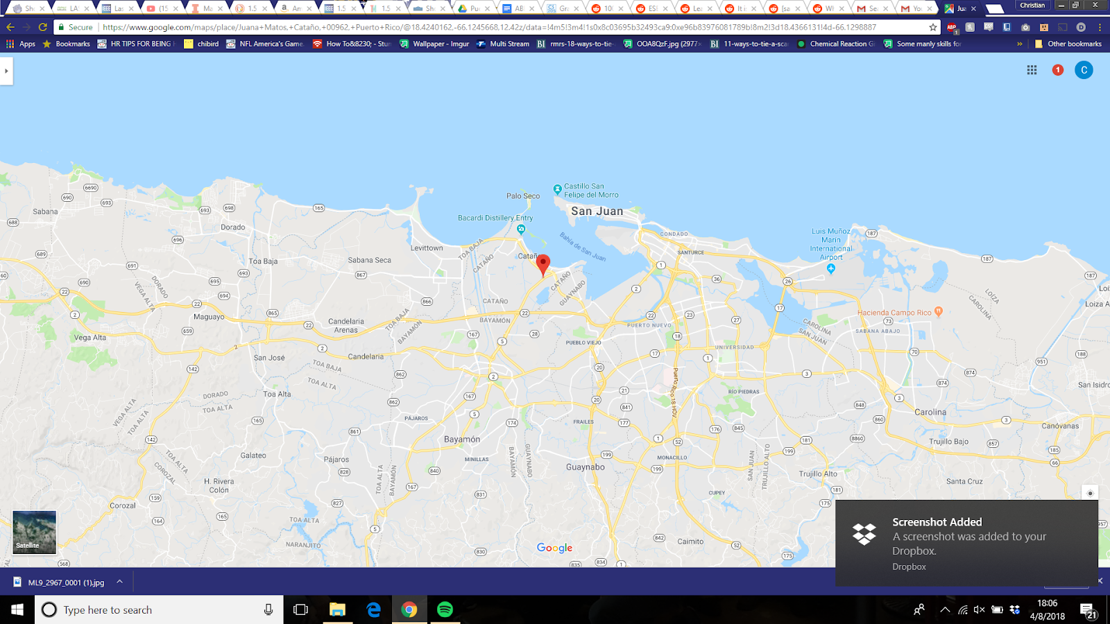
Figure 1: Juana Matos on a map (Source: Google Maps)
Project Objectives
Project Objectives
Our main goal was to assess and document major infrastructure damage in the neighborhood of Juana Matos located in Cataño, Puerto Rico. We used our smartphones (iPhones and Androids) to take photos and sync them to the Fulcrum application. Fulcrum was used to capture photos and “geo-tag” them to the location it was taken so that we can later view them in relation to its position on the map. We were able to categorize our photos based on the type of infrastructure, the type of damage, and what kind of natural disaster that had caused the damage.
In order to closely access these damages, we needed a device that would perform well despite the weather and climate, and human error, so we used a stabilizing camera that was able to capture clear, high-definition photos. We also used a Go-Pro to take videos and provide voice-over feedback on what was being recorded. Using this additional method was meant to educate those on the subject matter when showcasing this project through footage, and to remind us of what exactly we came across while we worked on our evaluation/at-home assessment.
Most damages were caused by the hurricane, but others were due to the lack of maintenance over the years and lack of funding in order to upkeep it.
Although we did not converse with a lot of local community members, we did come across one that was concerned about our presence. We explained our project and our intentions to ensure that we were not there to invade their home or neighborhood seeing that we were roaming around with devices taking pictures. After talking to the community member, we gained a lot of insight in regards to local infrastructure histories of Juana Matos, the local histories of the citizens/squatters, as well as the existent and non-existent systemic structures that govern that neighborhood.
Project Team
Blake Banks:Blake is a senior in Agricultural and Biological Engineering and plans to research biofuels. She enjoys reading, playing softball, and hanging out with her niece.| Margaret Bono: Maggie is a freshman in Civil Engineering. She is focusing on a primary concentration in environmental with a secondary in water resources. |
Samuel Dotson: Sam is a junior in Engineering Physics and is interested in everything. He plans on attending graduate school for physics.
Leo Fouts: Leo is a Freshman majoring in Civil Engineering. In his free time, he is involved with Volunteer Illini Projects.
Kelsey Handschuh: Kelsey is a Sophomore in the business program. She is pursuing a management degree with two minors in CS and Statistics.
Carolina Kuhl: Carolina is a junior majoring in Human Development and Family Studies with a concentration in Child and Adolescent Development. She is also minoring in Latino/a Studies and Psychology. She hopes to attend graduate school for Social Work and Ethnic/Cultural Studies.
Robert McCormick: Robert is senior in Crop Sciences. He would like to seek a career in the health professions
Christian Reichert: Christian Reichert is a senior in Engineering Mechanics, with Mechanical Design as his secondary field.
David Rivera: David is a freshman in Civil Engineering who looks to focus in Energy-Water-Environmental Sustainability.
Findings
Throughout our assessment, we found a number of infrastructure concerns including clogged and broken drainage systems, damaged structures, an excess of debris in the streets, and a backed up canal.
Clogged Drains
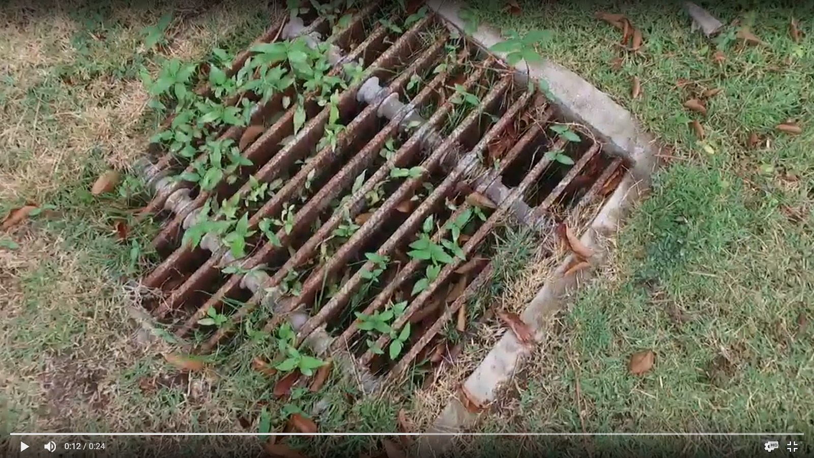
Figure x shows a number of weeds growing on top of a drain grate. Some grass has also grown over the edges. Similarly, a mass of mud, leaves, and trash clogs a drain on the side of the road in Figure x. These obstructions prevent water from leaving the area when rain falls.
Figure x: Weeds growing on a drain grate
Figure x: Leaves, mud, and trash piled at a drain
Damaged Drains
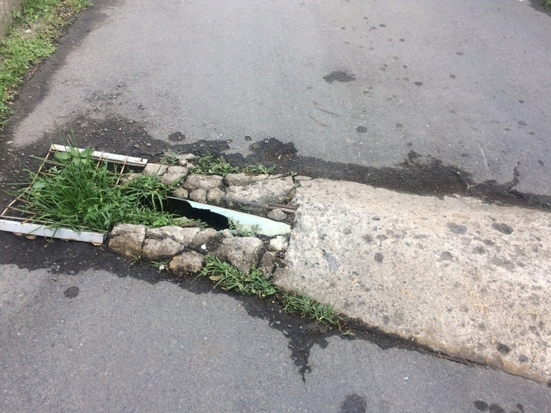
Often times the drainage issues are caused by damaged structures. Presumably at one point Figure x had some kind of cover but since it is missing or broken, leaves and trash can fill the space, preventing water from flowing through. Another common sight is eroded roads, like in Figure x. This is likely due to water constantly flowing to this drain, which again is ineffective because it is packed with mud and other debris. Due to likely low structural integrity from being continuously submerged in water, this concrete reinforcement in Figure x may have been crushed after a car drove over it or worn away over time. With no protection, the pipe also broke and is now futile in transporting water to the designated location.
Figure x: Drain missing its cover; Figure x: Mud and trash-packed drain with eroded road
Figure x: Exposed pipe and broken concrete reinforcement
Damaged Structures
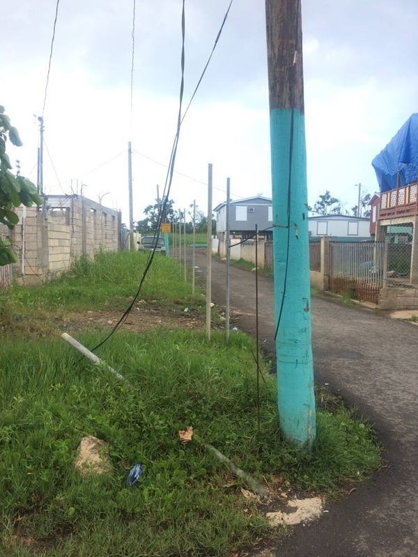
High hurricane winds blew over poles, knocked down telephone or power lines, and bent street lights as shown in Figures x and x. The exposed wires are particularly concerning because there is the risk of electric shock, especially by someone not familiar with the area or a curious child. As with the concrete support in Figure x, the integrity of these bases may have already been compromised due to sitting water.
Figure x: Fallen fence pole and telephone or power line; Figure x: Leaning street light
While we were not completely certain of the purpose of the system in Figure x, it seems to pipe water from one place to another. Perhaps the door was blown off with the hurricane winds or began to crumble over time. Either way, the pipes inside are no longer protected and are at a greater risk of being damaged in the future.
Figure x: Exposed pipes in concrete box
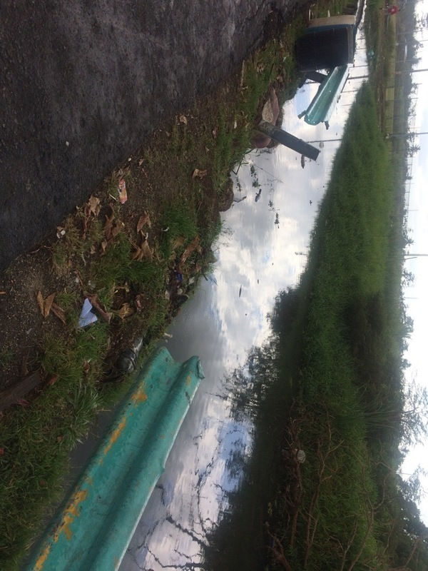
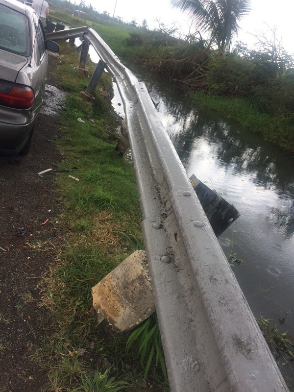
Several sections of the guardrail by the canal were either missing or uprooted from the ground, like in Figures x and x. This presents concerns for people or even cars falling into the canal. In Figure x one of the concrete supports is completely lifted out of the ground with others partially raised. Erosion and saturated soil prevents the guardrail from being securely held in place. It is also possible that these damaged structures are simply old and there are no funds to fix or replace them.
Figure x: Missing section of guardrail between canal and road
Figure x: Guardrail concrete supports lifted out of ground
Trash and Debris
As we walked along the streets of Juana Matos, we saw a great deal of garbage littered in the streets. Trash may have been intentionally discarded this way due to lack of set disposal systems or displaced from wind and water. Figures x and x show large amounts of debris in piles of soil. A surge of water could have moved the soil from its original location.

Figure x: Piles of debris beside the canal
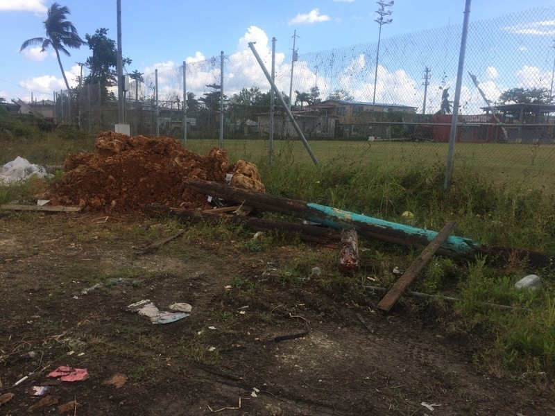
Figure x: Pile of debris next to the baseball stadium
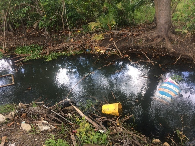
Backed Up Canal
In addition to trash on the streets, there is also a lot in the canal, as shown in Figure x. Causing more concern is the raw sewage dumped into the canal due to the lack of a central sanitary system. The canal is not healthy, which is noticeable by its black water and foul odor. The excess of nutrients causes a number of invasive species as well as other plants to grow inside, as depicted in Figure x. Instead of allowing water to flow to the ocean, as shown in Figure x in Appendix 2, the canal is cut off in several sections.
Figure x: Canal with debris inside and surrounding
Figure x: Canal cut off by vegetation and debris on the adjacent land
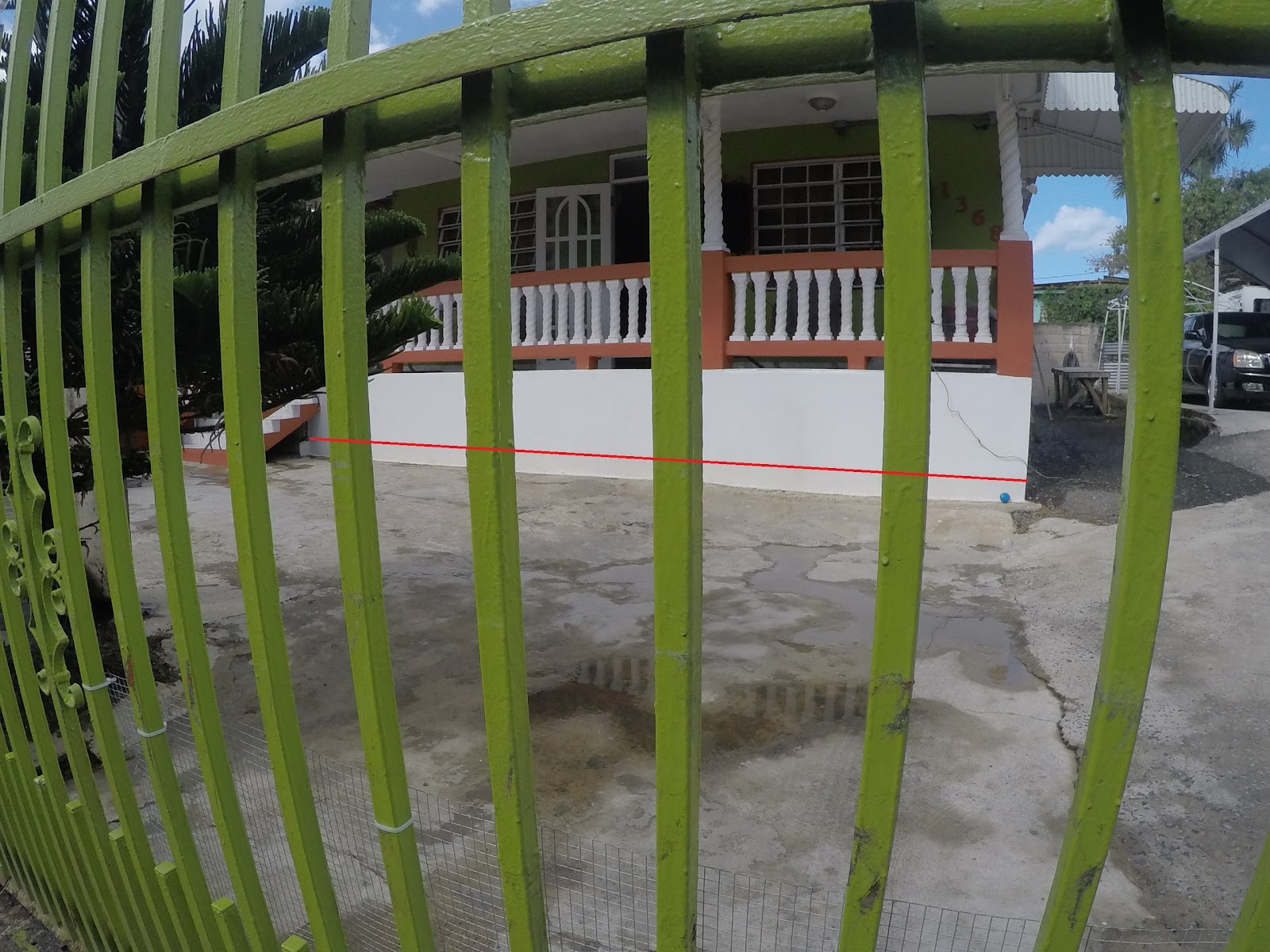
This clogged and overgrown canal prevents water from moving out of Juana Matos, which is already at risk of flooding due to being located on a wetland. This can be supported by our conversation with a member of the community. He told us that everytime it rains, it floods. Figure x shows a line on his house from the persistent flooding. The poor state of the canal is causing many issues in the community.
Figure x: Water line on house from constant flooding (highlighted with red)
Recommendations
Our recommendations span from short-term, low financing options, to long-term, more critical investment options for Juana Matos. We are aware that these areas need help, direction, and money. So, we included various options for the community to choose from and think about as they go further in their investments. For starters, we realized that Juana Matos has a strong sense of community and we wanted to use that to further benefit this area. Therefore, our first short-term recommendation is to boost community involvement by organizing a designated day of work on a weekly basis. We would also want to add an education aspect to these days.
In order to organize these days, the community leaders and Caras con Causa would have to be incredibly commutative with all of the citizens in the community. So, we would suggest setting the same day and time every week, like choosing Saturday morning at 10:00am for two hours, and spreading the word. To ensure that people will want to participate, emphasis that this is a great way to spend time with their family and children as well as helping out the community that they live in. These days could cover a range of things to be done. They could include work in the mangroves, jobs that people have requested, painting, or even trash clean-up. At the end of the two-hour community work, there could be a potluck provided by various community members as a way to relax and reflect.
During these community involvement sessions, it would be a perfect opportunity to deliberately include important educational topics that are most dire to the citizens of Juana Matos. These topics would change based on that week’s chosen job. For example, if there was a day that the community was working in the mangroves, one of the leaders could teach more about the importance of the wetlands. On a day where the community were to pick up trash, one of the leaders could teach more about pollution and the current issues facing the world, Puerto Rico, and even just Juana Matos.
We believe that a clean community can create a more positive atmosphere. Another short term recommendation that we have is to get the trash and solid pollution problem facing Juana Matos under control. Although we are not as familiar with the trash collection services available to Juana Matos’ citizens as we are in our community, we believe one of the main issues is simply not having a central location for the community members to actually put their trash, like a dumpster. So, we suggest two options to solve this problem. One is to talk to the government about issuing a free dumpster to the community as well as ensuring the trash collection on a weekly basis. The other option we came up with is to use a local waste disposal and trash pickup business called “Republic Services”. This business is located relatively close to Juana Matos and has fair prices to pay for a cleaner neighborhood. While the prices range based on what the leaders in Juana Matos would want for this community, we believe this would be a good option to look into. They have public private partnerships so that, even if there are squatters in the community, they would be taken care of and issued garbage cans under a contract. Not only that, but they could also pick up the trash on a weekly basis. Republic Services is working on over 70 renewable energy projects currently which include two solar energy landfill covers that are creating energy by simply covering garbage. So, while these short-term recommendations could already make huge change, the intermediate recommendations go even more in depth of how to help Juana Matos.
We have identified the canal near the entrance to La Reserva Natural Ciénaga Las Cucharillas as one of the more pressing issues of the community. The invasive plants in the canal easily multiply and absorb the oxygen and reduce the nutrients in the water. This process of eutrophication leads to the loss of the natural wildlife. At one point in the canal, the invasive species halt the flow of the canal completely. There is also a significant amount of debris in the water. This may be due to the flow of the hurricane, but we also believe it may be due to people deliberately throwing their trash in.
Our recommendation is to partner with universities on the island and have them conduct a number of feasibility studies and environmental surveys. These would include a hydrological study to document the rainfall and its natural flow through the community, an infrastructure assessment on the existing drainage and sewage systems, assessments on the state of the canal, air and water quality tests, and a health survey of the community as a whole. Through the health survey we’d look to determine if members of the community are prone to any illnesses that may be due to their environment.
We would also like to establish a correspondence with a university on the island. We would like to establish a class here at the University of Illinois that is paired with a class in Puerto Rico where we could collaborate on projects. An idea would be to have the class in Puerto Rico gather findings and send it to the class in Illinois where we could conduct further research and suggest possible solutions.
Two professors at Illinois that would be interested in a project like this are Jeffery R. Roesler of the Civil and Environmental Engineering department and Luis F. Rodriguez of the Agricultural and Biological Engineering Department. Professor Roesler conducts research on Construction Materials and Transportation Engineering. Professor Rodriguez conducts research on Big Data, Modeling, and Analytics, Social Constraints on Engineered Systems, Reliability and Sustainability, Decision support, and Life support systems. Professor Roesler can be contacted at jroesler@illinois.edu. Professor Rodriguez can be contacted at lfr@illinois.edu.
Our goal from completing the multitude of assessments would be to suggest logical long term solutions. These assessments would make sure that the community would be spending their money as efficiently as possible. One long term solution we believe will potiently help the area with constant flooding is a scheduled cleaning and dredging of the canal. Dredging itself would increase the volume of the canal, allowing the canal to hold more stormwater. The canal has a bend to it, and continues in a direction that ultimately flows into a larger canal. Another solution is we could widen the canal in areas of unused space. Both of these forms of dredging could help reduce flood damage in the future. As of now, the canal’s flow is halted completely by invasive plants. This heavy level of eutrophication increases runoff levels. However, if the canal was cleaned, the canal would be able to flow into larger bodies of water. These species of plants can grow back very quickly, so a more expensive way to prevent sediment levels in water from increasing would be to line the canal. The impermeable layer of concrete is a proven way to stop weed growth. The speed of the water can flow at a faster rate, and good construction will allow the structure to remain for a very long time. Perhaps a cheap alternative to using concrete would be to use clay. The soil in the Juana Matos region contains a lot of clay already, so it can be refined and compacted tightly to work properly.
Additionally, looking into how the community of Juana Matos handles their sewage would be a way to ensure the purity of the water flooding homes. By asking residents of the area, we can determine what type of waste management is the most prone to the constant flooding. A possible solution would be to convert all homes to having access to a sewage treatment plant. Another potential fix to the area would be installing a detention pond. Simply put, “[A detention pond’s] purpose is to slow
down water flow and hold it for a short period of time such as 24 hours. Urban areas rely on these
structures to reduce peak runoff rates associated with storms, decreasing flood damage” (Laramie County Conservation District). To our knowledge, lots near the canal are no longer in use due to Hurricane Maria. Therefore, we could use these lots and install a nearby detention pond to allow for additional storage of stormwater during rainfall periods. Finally, we believe that the community should continue to invest time and money into Mangrove reforestation. These trees native to the environment will soak up lots of water and secure the soil so invasive species cannot grow at an alarming rate.
Summary
In this evaluation, we have learned that constant flooding affects the quality of life for the individuals living in Juana Matos. There are some significant factors limiting restoration to the area. The leading issue pertains to land rights; with this issue, the process for seeking aid and additional funds for the area becomes more difficult. The squatting in the area complicates the incentives for third parties to get involved. Another issue can be found in geographical challenges such as elevation lower than sea level and constant heavy rain. This may suggest that new infrastructure should be considered to combat these challenges. Next, we focused our evaluations on existing infrastructure for restoration, community member conversation, and general observations on the surrounding. The next step, after these preliminary evaluations is to develop a feasibility plan that uses various studies that collects numerical data on the area. These studies will include a hydrological study to assess that amount of water produced in the area, where the water flows, and how it is absorbed. Another study would be an infrastructure assessment which assesses the existing drainage system. This study will find data on how much water that the current system can handle and whether there are obstructions affecting performance in the drainage network. These tests would have to be conducted by students under the supervision of trained civil engineers. Once the analysis and data are collected, we suggest a collaboration with a professional either from a university or reputable company. These professionals can use this data to formulate a plan that would be the best course of action to alleviate the flooding in the area of Juana Matos. These plans can look at possible solutions including dredging the canal that is neighboring the community, maximizing drainage flow of the existing drainage system, and ensure proper disposal system of waste and trash. The last step is to find funds to carry out the developed plan either through a company that would have a connection or motive to develop the area or through applying for grants. Having proper data and a feasible plan would make a strong grant proposal and increase the incentive for third-party aid.
Appendices
Appendix 1
Land rights in the region
Many of the poorer neighbourhoods in Cataño were settled unofficially. Places like Juana Matos, and other communities near the estuaries were wetlands, which were slowly and without planning settled. Hundreds of people in these communities do not own the land on which they live. The government would provide some services, but due to the lack of proper planning for these communities they were not sufficient, and as a result the people that live there would lack modern infrastructure. With no proper sewage system, some houses use cisterns while others dispense their waste into nearby bodies of water. This creates health risks, exacerbated by the constant flooding of these neighbourhoods, bringing sewage into contact with the residents. It has been an uphill fight for these communities to properly establish themselves. Some communities are fighting for community land titles, which will give residents legitimacy for their own homes.
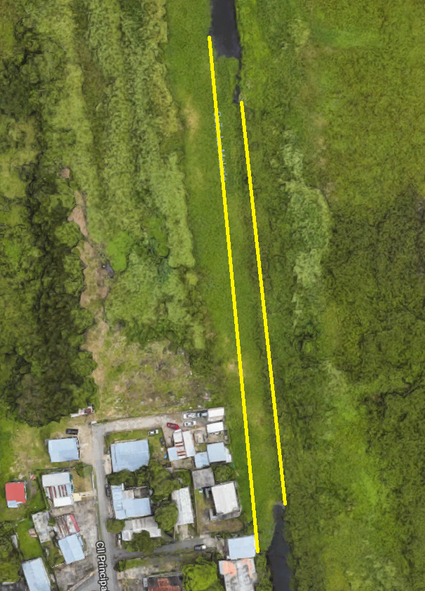
Appendix 2Google Maps images of canal path
This section contains aerial images of Caño La Malaria. The area between the yellow lines should be water but instead there is vegetation growing.
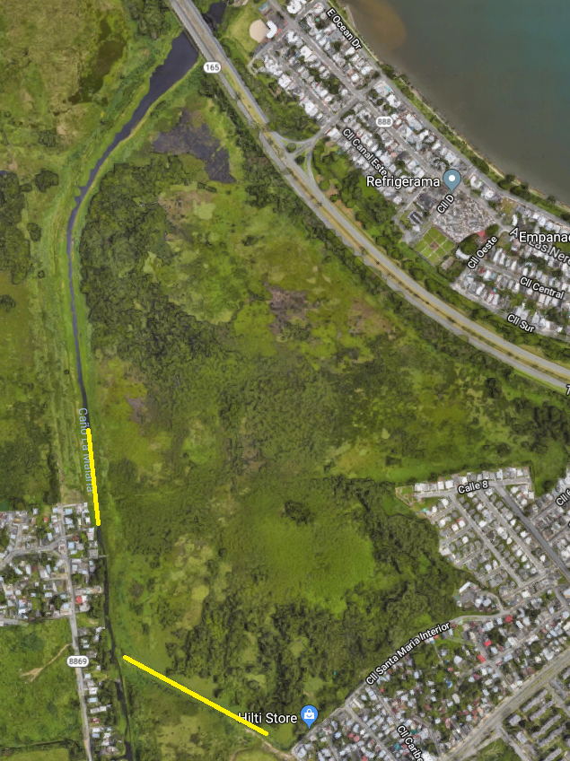
Figure x: Long shot of Caño La Malaria and segments cut off by vegetation (Source: Google Maps)

Figure x: Medium shot of Caño La Malaria and segments cut off by vegetation (Source: Google Maps)
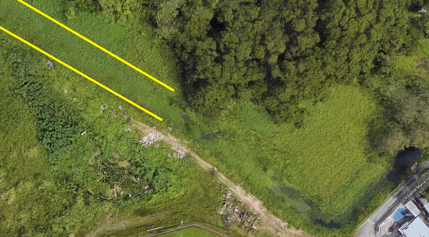
Figure x: Close up of Caño La Malaria and segments cut off by vegetation (Source: Google Maps)
Figure x: Medium shot of Caño La Malaria and segments cut off by vegetation (Source: Google Maps)
Figure x: Close up of Caño La Malaria and segments cut off by vegetation (Source: Google Maps)
Appendix 3
This appendix will contain contacts for professionals that can provide more information. These individuals may have experience in the possible solution described above.

Comments
Post a Comment